Lets admit it. Vancouver doesn’t have a pedestrian street. We are lagging behind Montreal, Beijing, Copenhagen… and Calgary 😮
Lets also conclude that Granville street will not be permanently pedestrianized in the foreseeable future. It’s a huge headache for Transit and millions of dollars have already been spent on rebuilding it as a Transit Mall.
I say we pedestrianize Water Street!?
5) It doesn’t affect transit (or at least not significantly).
Closing Granville Street to transit was not originally planned to happen. It was designated as a Transit Mall with extra wide sidewalks on both sides. Now that the transit lanes on Seymour and Howe have been replaced with parking, closing Granville Street will significantly delay all the buses that run on there.
Closing off Robson Street is simply a headache for the 5 bus.
In contrast, pedestrianizing Water Street will minimally affect transit (explained below).
4) It will help business
After Times Square and Broadway was closed to cars in 2009, business soared. In every city around the world, pedestrian malls themselves have shown to be one of the most popular attractions in the city. As the people walking past the stores increases, retail vacancies will decrease, greatly improving the activity of Water Street.
3) It’s a crutial cycling connection
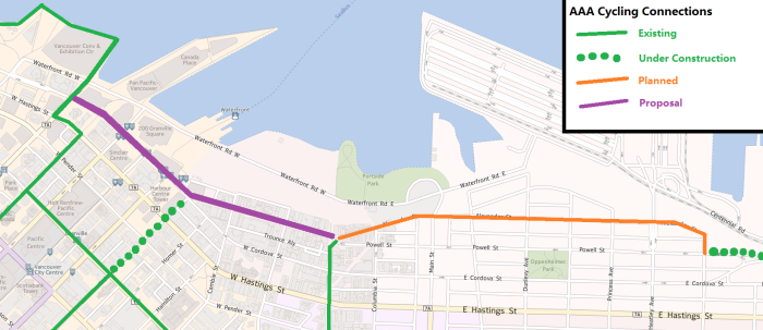
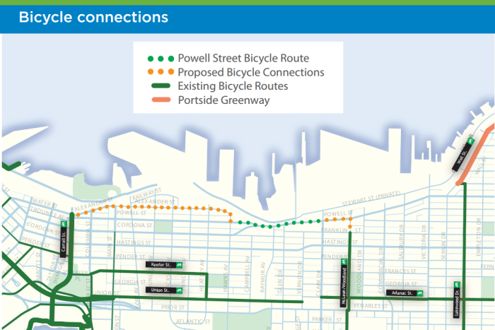
After Point Grey, Water Street is the single biggest gap in Vancouver’s cycling network. AAA Cycling Facilities are already being built on Powell Street (image below), and the connection between Canada Place and Carrall Street is the most dangerous. Currently, the only connection is on Pender Street by sharing the lane with buses and parked cars.
Water Street would also serve as an extension of the seawall, Canada’s #1 public space.
Creating a two way bike connection on Water Street will take up less than 3 metres of space, leaving more than 12 metres for pedestrians.
2) Water Street is the most natural street to be pedestrianized.
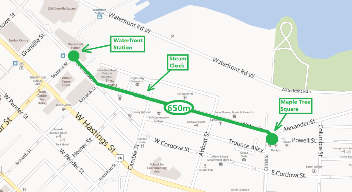
Water Street is Vancouver’s downtown’s anchor tourist attraction. The main attractions are the world’s most famous steam clock (yesterday was its 36th birthday), and the Gassy “Jack” Statue. Gastown and Water Street’s street design alone attracts tourists. Most businesses along Water contribute to the unique feel of the street. These include the numerous tourist-oriented gift shops and eateries.
Water is a true mixed use, mid-rise environment built before zoning laws and urban revival. The street possesses ground level retail, dense but light residential, and office spaces.
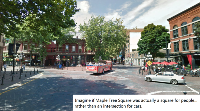
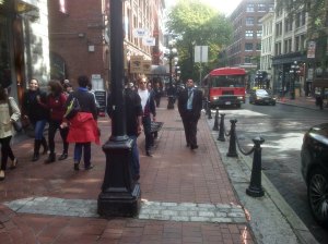
The street’s infrastructure greatly contributes to its feel. Water is meant to look like an Old European Street. It has cobblestone (brick) pavement, low or no curbs, antique-looking lamps and fence posts, and old brick buildings. Water street is a “small street” lined with trees and stone architecture.
Water feels like a vibrant street because its street design produces life. People flock to Water Street because there are other people. Restaurant patio seating (such as for Canada’s first old spaghetti factory) is designed to contribute to the positive environment. Every time I go to Water Street, I feel liberated by the squawking tourists. What is most amazing about Water is that droves of people can be seen walking all day, everyday.
And plus, “Water” Street has a cool name.
1) Vancouver needs a pedestrian street.
Vancouver was at one point, the world’s most livable city. What did Vancouver do? It focused on building city spaces that encouraged city life. In 1997, Vancouver committed to a transportation plan that explicitly stated that there would not be any increase in road capacity. Vancouver prioritized pedestrians. But now, Melbourne has claimed the title of world’s most livable city. It has pedestrian streets and Vancouver doesn’t.
Across the world, streets that are dedicated to pedestrians are one of the most vibrant in the city. These streets see huge numbers of people enjoying the urban atmosphere and interacting with society. It’s time for Vancouver to build a pedestrian street.
Show your support here:
Thanks for your support! After this, we’ll be addicted to creating pedestrian streets. Maybe we’ll pedestrianize Robson, then Mainland and Hamilton… But Water Street must come first.
* * *
Specs & Other stuff:
Effect on Transit:
Closing water street actually affects one bus. The 50 bus SB goes has one stop on Water Street. It can easily use Pender instead, but there is a better solution. The formal terminus of the 50 is “Waterfront Station”, and few passengers go further than that. In other words, the bus is pretty much empty between Andy Livingstone Park and Waterfront. It would be better just to simply cut the 50 bus at Waterfront Station!
Closing Water Street will actually speed up transit, because it will eliminate the overly complex and inefficient intersection of Water-Cordova-Richards. This intersection has a cycle of 1m05s. By my count, more than 30 buses use that intersection every hour.
Effect on Vehicle Traffic:
There have been many traffic volume analyses done on this corridor in recent history. First and foremost, motor vehicle traffic has been decreasing rapidly, and will continue to do so. Car traffic entering the downtown peninsula is below 1965 levels, even with population doubling. The traffic volumes during Olympics offered a perspective of the maximum capacity of the E/W streets entering downtown [Figure 12; P. 31] . There was no study done on Water Street, but counts have taken place on Powell Street at Main. Although Water street is the extension of Powell Street, because it has one lane compared to Powell’s two, and because Water Street possesses natural traffic calming measures, Water will carry significantly less traffic than Powell Street at Main. Data obtained from VanMap showed that 100 block Water street sees 0.75X the amount of traffic volume that Powell gets at Main. Even if all the 1200 vehicle morning rush Powell Street traffic was diverted, adjacent streets Hastings, Pender and Expo Boulevard would greatly exceed the capacity needed to accommodate the increase in traffic.
The most significant evidence that closing Water Street will have a insignificant effect on traffic is shown by the recent closure of Powell Street and Cordova Street for the construction of an overpass. Naturally, one would think that the 1200 vehicles that used to use Powell Street W/B in the morning rush would completely clog up the only adjacent street: Hastings. This has not happened. Though commute times may have risen slightly, no dramatic effect has occurred by closing the major arterial entering downtown. Because Water Street carries less than half the traffic that Powell does at Main, and because there is significantly more road capacity along streets adjacent to Water than there is on the street adjacent to Powell (where the current closure is), it is safe to conclude that no congestion will result from the closure of Water Street.
Cost Implications:
Capital costs to pedestrianize Water Street are minimal. These may include the removal of fences, planters to prohibit through traffic, signs to assist with navigation, paint for a designated bike connection along Water, and the reprogramming of a couple traffic signals. This will account to much less than what the city spends each year on “Viva Vancouver”.
Car traffic has significantly worn down the 1972 cobblestone streets, resulting in the city committing to fill in holes with asphalt. The city would reap long term savings from not needing to do pavement repairs.
The construction of the bike connection and sidewalk improvements between Richards and Burrard will cost about $550,000 based on the costs of the Dunsmuir and Hornby Lanes.
Effect on Business:
Sales along Water Street will greatly increase due to the influx of pedestrians. This will also increase the retail rents.
One problem that may result is gentrification. Gastown went through gentrification in the 1960s. As retail rates go up, businesses with more cash to rent each retail location may end up doing so. Though gentrification is unavoidable, because it is a relatively slow process, the best way to reduce gentrification is to build more pedestrian zones where business strives.
Business in other parts of the city and downtown should be unaffected. Pedestrian streets generally attract people who would not generally leave their homes to come downtown.
Unoccupied Storefronts:
Along Water Street, most businesses contribute to the street life, especially the ones with outdoor seating. The empty storefronts with posters on windows do not contribute to the street life, which is most evident along the half-block long parkade between Cambie and Abbott. Pedestrianizing Water street will decrease retail vacancies to almost zero, and encourage all retailers to open up their shops’ doors to contribute to the street life. A study done on the business impact of the Hornby Street Bike Lane showed that retail vacancy rates dropped from 12% to 2%.
Effect on Deliveries, Business & Residential Access:
Pedestrianizing Water street will remove five “commercial loading zones” on Water Street. Because the 100 blocks of Abbott, Cambie and Carrall are accessible by vehicle traffic, business should continue to be able to get their resources delivered efficiently. (100 block Carrall is accessed via the alley north of Water. This is currently the only way it can be accessed because turning onto Carrall from Water Street is prohibited. Because traffic along this lane is very small, minimal conflicts should arise.)
There is only one driveway along the whole stretch of Water Street for easypark. A small segment of road (less than 50m) will connect Cambie Street to the Parkade.
Access to Businesses and Residential should be greatly improved for pedestrians and cyclists, and slightly inhibited for motorists (see “Effect on Parking”).
Design Specs + Effect on Parking, Loading Zones & Tour Bus Zones:
| Cordova Street: Burrard to Howe | Separated Bike Lane on South Side.Removal of 4 parking spaces on North Side and 6 on South side plus relocation of 1 “India Consular” Parking space. Parking can be retained in the middle segment of the street with a 2.9m bike lane, 0.6 m buffer, 2.5m Parking on both sides, and 2 2.9m travel lanes. |
| Cordova Street: Howe to Granville | Bike Lane on south side requires the removal of 8 parking spaces and one commercial loading zone (about two spaces). |
| Cordova Street Granville to Seymour | Bike Lane on South Side can be added whilst retaining parking by narrowing the travel lanes and removing one travel lane. A bicycle crossing on the West side of the intersection of Cordova and Seymour will allow cyclists to travel between the north side and the south side of Cordova Street. |
| Cordova Street: Seymour to Richards | Because Water Street will be closed, there will no longer be any vehicle access to the North side Westbound Lane on Cordova Street between Richards and the Parking Lot. Between the Parking lot and Seymour, one lane Westbound would suffice. A bike lane and widening of the sidewalk can take place here with the extra lane space. |
| Water Street: Richards to Cambie | Pedestrianization of Water Street will restrict all vehicle access and allow a bike lane to be painted on Water Street (preferably the South Side).Removal/Relocation of 5 parking spaces, one Tour Bus Zone (about 5 spaces) on North Side, and 1 commercial loading zone (about 2 spaces) on South side. |
| Water Street: Cambie to Abbott | The entrance of the EasyPark Parking lot will require a small segment of road (<50m) for vehicle traffic to connect the lot with Cambie Street. Cyclists will share this segment of road with vehicle traffic.Note: There is much more than enough room in the Easy Park Lot to accomodate the lost parking along Water Street.Removal/Relocation of 1 Commercial-Loading/Bus zone (about 3 spaces), one Passenger/Commercial-Loading Zone (about 3 spaces), and 6 parking spaces on North side, and 1 passenger zone (about 2 spaces) and 3 parking spaces on South side. |
| Water Street: Abbott to Carrall | Removal/Relocation of 4 parking spaces, 1 commercial loading space, and 1 Tour Bus zone (about 7 spaces) on North side, and 1 commercial loading zone (about 2 spaces) on South Side |
| Intersection of Carrall at Powell: | The current complex intersection at Carrall and Powell will be replaced by a one travel-lane Powell Street that naturally curves into Carrall Street. Alexander street will intersect with Powell as East as possible before Powell turns into Carrall. The goal of this intersection is to leave as much space for pedestrians as possible, so that a large public space for pedestrians is created. |
| Totals: | Removed Parking: 36 spaces Removed/Relocated Commercial-Loading/Passenger Zones: 6 Relocated Tour Bus Zones: 2Total Distance of Bike Connection: 1.0km Total Distance of Water Street Pedestrianization (from Waterfront Station) 0.65km |
Economic Implications towards Economy:
Because the Provincial Government may sometimes have issues evaluating the economic impact of projects designed to improve city vitality, the benefits are explicitly listed below.
- Increased Tourism. Most tourists enjoy seeing people from different places, and pedestrian streets are a tourist’s paradise.
- Fewer roads dedicated to cars means decreased driving and fewer greenhouse gasses. Fewer people driving also decreases road maintenance costs.
- Increased business sales along pedestrian zones results in a stronger economy and more sales and income taxes collected.
- Studies show that people who live in urban areas are generally more intelligent and well informed about local issues.
- This is a positive project in a city, and will greatly help with reelection.
- Praise from the international community and increased investment in our province.
This would probably increase drunken foot-traffic in the neighbourhood, keeping me awake, but I’d support it anyways. Taking cars out of the design makes it easier to focus on safety between pedestrians and bikes. The Carrall Street bike paths are a bad example with bikes given weaving paths that pedestrians rightly treat as sidewalks. I don’t know how to save the Carrall St. bike paths without simply giving them to pedestrians and putting bicyclists back on the “street” portion. If the cars had another option than Carrall from Powell to Cordova that would make it a nice part of your car-free proposal. (Might eliminate the weird/dangerous “one way into a two way” intersection at Powell too.)
Great article and thank you for putting this matter forward. I agree with you and still want Granville St in the downtown and the bridge to become a walking and cycling mall. I do not mind if it becomes an active transportation mall including transit. It can be done and a couple of us met with the Transit CEO a few years ago to put forth suggestions of how to handle transit in a walking / cycling mall scenario. It can be done easily and effectively.
Regarding separated bike lanes, pleas do not suggest any width less than 4.5 metres. We need the room for passing and more importantly for social cycling. With social cycling (people cycling side by side and talking) will generate significant growth.
Pingback: How to Solve Vancouver’s Congestion Problem | 257van
Pingback: Manufacturing Controversy on Point Grey Road
Pingback: Vancouver Downtown Transit network: the local view | Voony's Blog